Login
Login
The Origin of the Constellations

Share

- Details
- Transcript
- Audio
- Downloads
- Extra Reading
Who invented the constellations? The constellations that we use to group stars into visually associated groups have ancient origins and have been hugely influential throughout human history. This lecture looked at the appearance of the ancient constellations and show how it is possible to deduce from their appearance when and where the first constellation makers lived. This leads to a curious historical puzzle since some famous commentators in the ancient world describe patterns of constellations that they could not have witnessed when and where they lived.
Download Transcript

25 January 2007
The Origin of the Constellations
Professor John Barrow
We are going to have a look at the constellations of stars that are so well known to us in many respects. The focus is going to be to try to show how the study of astronomy, the motion of the Earth and the solar system, can enable you to do some detective work as to when and who were responsible for the invention of what we now call the constellation patterns.
Constellations have played a curious role in human history. They have had a big impact on human imagination, in spheres as diverse as modern art, in religion, in astrology, in navigation of course – one of their original purposes was to guide navigators and travellers in the Mediterranean regions. If we look back through the history of art, we find many wonderful examples of the constellations being represented in grand form.
Whether you live in the north or the southern hemisphere makes a big difference. In a typical representation of the northern constellations, you can see some familiar candidates: the Plough in the middle. The Plough is something that appears in many cultures. It is a group of seven stars. We call it the Plough, the Americans call it the Big Dipper, the Ancient Mayans called it a parrot, the Chinese represented it as a chariot, the Egyptians as part of the thigh and leg of a bull, so everybody sees things differently. You should not take very seriously the idea that people who named these star patterns really did believe them to be looking like, say, a hunter or a plough. They were symbolic, almost certainly, for something associated with a hunter or a plough or whatever was being used as the image.
The northern sky I always think is something rather unspectacular. If you go to the Southern Hemisphere and look at the night sky from a really dark site, then you see something that is much more spectacular. The southern sky has the Magellanic Clouds, which are dwarf galaxies in the sky; the Southern Cross, rather than the Pole Star; there are just many, many more bright and spectacular star groups in the sky.
The best place for an ordinary person, who is not looking through a high-powered telescope, to see the sky is to take the opportunity, if it ever exists, to go to one of the world’s leading observatories, which you sometimes can just as a visitor. You do not want to use the telescope – that is going to enable you just to see a small area – but to stand outside, in the Canary Isles, at the telescope there, or in Hawaii, or at the Anglo-Australia telescope, which is on a mountain, because you are there at one of the world’s prime sites for looking at the sky – prime because it is dry and it’s clear. What you can see in the sky is quite fantastic.
We are used to seeing a relatively small number of stars if we are even in the country in England, but on a mountain top or an observatory site, you feel that you are seeing thousands upon thousands of stars; the whole of the sky is a tapestry of stars, and this is something that we no longer see where we live. You have to remember that people in ancient times, who created myths and legends and stories and images of the sky, were seeing something that was much more impressive, much more forceful than what we see today.
The sky was very much a focus for artistic representation, significance and meaning. The oldest recorded information that we have written down about the constellations we see today only goes back to about 270 BC. It is a poem we are going to have a look at later on, a rather serious prose poem. But the constellations that we use today, the names and the patterns, date from only about 150 AD. This is when they were reorganised. The person mainly responsible was Ptolemy, who wrote a work which is now lost to us, but we know of it through its Arab translation and the name given to it, Almagest. This was a summary of Greek knowledge about astronomy and the universe.
You get a rather curious amalgamation of different cultures because of the merging of Arab star names and Arab astronomical information with what was in Ptolemy’s original book. What you end up with, as a result of Ptolemy’s work, and the Arab action on it, is a system of constellations, groups of stars which were defined by the Greeks. The constellations have Latin names, thanks to that Ptolemic system, but the stars in them often have Arab names. So the Arabs used the names that they already had, created by the Bedouins and others, labelled the individual stars, whereas someone like Ptolemy would have described stars rather more vaguely; they would be described by where they were. So “The reddish star on the southern edge of this group,” is how he might describe a particular star, but the Arabs would just call it Aldebaran, which we would still today: it would be a name for a particular star.
Ptolemy’s system produced a catalogue of about 1,022 stars in nearly 50 constellations. There were about 48 at that time. After that, gradually navigators, people mapping the sky for practical purposes, started to create other constellations; identify other groups of stars where there were gaps. If you were a navigator, particularly in the Tropics or the Southern Hemisphere, you want to make sure the whole sky is covered. So there was a gradual evolution in the number of constellations and the modern number is different from the ancient number.
In about 1678, Edmund Halley, who we know of through his comet, was very much involved in mapping the Southern Hemisphere and the Earth’s magnetic field in great detail. He attempted to introduce a new constellation, named after Charles II. He wanted to call it Robur Carolinum, Charles’ oak, so he was obviously a crawler!
This technique is still used. I remember just a few years ago, when the physicists were worried that the super-conducting supercollider project was going to be scrapped by the US Congress, despite already spending billions of dollars, and they renamed it the Ronald Reagan Centre for Particle Physics! But it did not save it! Unfortunately, Charles II’s constellation disappeared almost as quickly as it was proposed, because the next formal mapping of constellations was being done by French astronomers, who simply ignored that new addition.
Things became settled into the form we now recognise only in 1922, when the International Astronomical Union agreed on 88 constellations, and that is the situation now. The reason that they have formal meetings that talk about such things is that they are not just trying to tell you what are the star signs for your horoscopes and things like that, but constellations were used to define and map the whole of the sky. So you should imagine that the whole of the sky is divided, rather like the map of the United States, into separate size regions. Each region has got one and only one constellation in it, and so if you want to say where something is in the universe, even if it is far in the background to the stars, you can identify it by saying that it is in Leo or it is in Taurus. So it is just a way of producing a map of counties, if you like, around the sky. Every known star, every nebula, everything that you want to look at in the universe lies in one of these regions, so that you can uniquely and completely describe what is out there to fellow astronomers by referring to the location in a constellation.
What are these 88 official constellations? You could make a little catalogue. There are 14 people, 9 birds, a couple of insects, 19 land animals, and so on in the list. There is a serpent, a dragon, a flying horse, there is even a river, and there are 29 inanimate objects – things like the Scales, the Plough and so forth. There is a menagerie of things that people wish to be seeing up in the sky, and those original names, those ideas for those constellations, are of course ancient ones, for the most part.
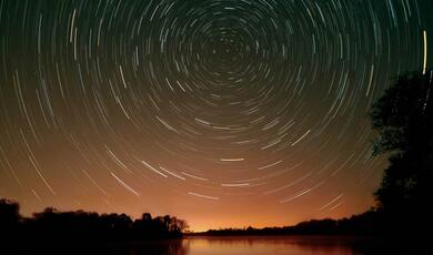
Let us start to look at some astronomy to understand what is going on when we look at the sky and how it might have come about that people wanted to define those groups of stars. If we imagine ourselves sitting here and looking at the universe around us, then the Earth has a rotation axis, which is pretty close to running through the North and South Pole. So you should imagine the rotation axis direction that the Earth rotates around. As a result of the rotation of the Earth, if you watch a fixed star far, far away, it appears to rotate around you in the other direction. So the stars rise at some point, on the Eastern horizon say, they travel up the sky to the highest point, and then they drop and they set in the West.
But not all stars do that. So as we look around us, there are three regions that you should think about in the sky. There are stars which indeed do rise, they go up to their highest point and then they come down and they set, and you do not see them again, so the observer can only see above this circular plane.
There are some stars which perform that circular route, and you see them all the time, and they are called the circum-polar stars. Some stars, like the Great Bear or Cassiopeia, are like this, so you see them in the sky all the time that it is dark. The size of that region where you can see the stars going around all the time is determined by your latitude. If you are at a latitude of L degrees north, then that determines the size of that region of the stars that you can see all the time. The smaller the latitude, the smaller this region is going to be. So as you go down to half our latitude and you get near the Equator, there is going to be a smaller region, fewer stars, that you can see in that way. As you get near the Poles and your latitude gets bigger, then you will see more.
As a counterpart, there is another region of stars which rise and set on orbits which never come above our horizon. So for us, we call these the southern circum-polar stars. We never see those stars, so that would be a blank spot on any map that we created of the appearance of the sky. Remember these important features: there are some stars that we see all the time; some stars that rise and then set; and some that we never see.
Suppose you do look towards the north celestial pole. At the moment, there is a star there that we call the Pole Star. That defines that direction there, and the stars that you always see will trace out circular obits on the sky around the Pole Star. It is interesting, if you start to look at ancient myths and legends and stories about the sky, that in northern hemispheres, particularly in Scandinavia and the far north, you find that mythology is populated by stories about the Great Millstone, the great, grinding, circular motion in the sky. The appearance of the night sky, the preferred direction that was on offer in the sky, around which everything seemed to circle, had a special, magnetic mythological status in many different cultures. There was a famous book written about this by Von Dechend and Santillana called “Hamlet’s Mill”, the myth of the great millstone in the sky.
When people first started exploring, culturally, cultures near the Tropics, were very mystified at first how people had a quite different picture and historical tradition and mythological interpretation of the sky, Eventually, they woke up to the fact that this was attached to what you should see of the sky if you lived near the Tropics. Suppose we live roughly where we do, and you are at Stonehenge, on a latitude of 51 degrees, what do you see when you look at the sky? Well, you have your Millstone in the Sky, everything going round in circles, but for the most part, stars rise, reach their highest point, and then come down and set.
If you go to the Equator, so the latitude goes to zero, you can see what happens. The inclined orbits move round, and all the stars seem to come up, go above you, and come down and set, so you think you are the centre of the universe. It is a very impressive scenario. Everything seems to revolve around you. There is no place visible on the sky. There is no Great Millstone. There is no point to which everything seems to be converging in the universe.
If you live up near the North Pole, if you are a Laplander, you see something very, very different again. The latitude then is being slipped up to 90 degrees, the stars do not rise and set – they all go round in circles above you. If you have this focus on the sky, it is actually up to the North Celestial Pole above you.
There are people who study the correlation between sky legends, people’s interpretation of the sky, and the latitude at which they live. You have a very different conception of the universe in very ancient times depending on the latitude of where you are.
Let us just focus on the apparent motion of the Sun. As you go round the year, the Earth orbits the Sun, but from our vantage point, we see the Sun moving around 360 degrees on the sky. Because our rotation axis is tilted at 23 degrees relative to the plane in which the Earth is orbiting the Sun, that apparent motion you should regard as being tilted by the same amount.
What we recognise, and what all our horoscopes in the wrong newspapers are based upon, is the ancient historical tradition that when you watch the Sun as it goes around that annual path of 360 degrees on the sky, it passes through a sequence of 12 impressive constellations, and it is those 12 constellations that mark out the annual passage of the Sun on the sky that we know as the signs of the zodiac. The signs of the zodiac are not the same as the constellations; they are a group of 12 constellations which mark out the Sun’s path. As the path is 360 degrees and there are 12 of them, then there are 30 degrees of zone to mark each one. By convention, they are regarded as about 18 degrees wide on the sky. You can speculate (there is little evidence) that once upon a time there might have been a system of the zodiac, systems of the constellations for other purposes, and they were merged to create this dual system.
The zodiac, by the way, just means a circle of animals. So if you look at that path that the Sun follows – if you think of what you would see on the sky as the Sun moves around its annual cycle – month by month, the Sun would be in the so-called House of Capricorn or Sagittarius or Libra or whatever. There is a rather interesting way in which one might understand how it came about that those 12 constellations were picked out, why they have this special status, why you might have wanted to define something like the zodiac. To understand that, and also the origin of the constellations, we have to know one other important thing about the dynamics of the Earth.
As I have indicated already, if you consider the plane in which the Earth is orbiting around the Sun, the Earth is spinning on its axis once a day, but that axis is not vertical. The axis of the North and the South Pole is inclined to the vertical, it is oblique by about 23.5 degrees, and that is why we have seasons. If the Earth’s rotation axis was perpendicular to the plane of the orbit, there would be no seasons. So the tilt means that when you are in one place, the Northern Hemisphere is closer to the Sun, and six months later, it is further away from the Sun. It is the tilt of the rotation axis with respect to the orbital plane that creates the seasons.
But that tilt has another unusual property, that was first noticed by the great astronomer of ancient times, Hipparchus. Hipparchus lived about 190 to 120 BC. He was a Librarian, perhaps at the Library of Alexandria. He was a most remarkable astronomer, and by studying both his own observations and others in meticulous detail, he deduced that this rotation, this angle of tilt of the Earth’s rotation axis was precessing. What does that mean? Well, suppose you have a little top, like those little toy ones you used to have. If you start it spinning when it is perfectly vertically upright, then it just spins like that, but if you give it a little nudge, what happens, as it spins, it starts to trace out a little circle. The rotation axis changes, so we say that it precesses. The Earth’s rotation axis does the same. The perturbations are coming from gravity and other forces in the solar system. It takes about 26,000 years for the Earth’s rotation axis to complete a whole precession circle on the sky. This was something that was first discovered, most remarkably, by Hipparchus.
One of the consequences of that is that the sky looks very different to people in different epochs in cosmic history. At the moment, our rotation axis, the North Pole, points towards a particular star, that we call the Pole Star or Polaris, but go back a few thousand years, or go forward a few thousand years into the future, and our rotation axis will be pointing in a completely different direction, may be at no star whatsoever or at a completely different star.
Shakespeare for example, in Julius Caesar, has a famous line where Shakespeare describes that Caesar is “constant as the northern star”. This is a complete anachronism: there was no northern star in Caesar’s day, although there was of course in Shakespeare’s. At the moment, 1950 to 2000, we are pointing towards the star that we call Polaris. If we go backwards 1200 years, we were not really near anywhere. Go back 4,500 years, again, it is not very exciting. Way back, and you were at Lyra. Go into the future, near Cygnus, round again to Lyra. It takes 26,000 years to go round this little loop.
This recognition has led to a very interesting speculation about what the origin of the zodiacal constellations might have been. It was made by a Russian historian in astronomy called Alex Gerstein. I rather like it. It is simple and it is quite sensible. That because we know that this procession takes 26,000 years, and we have 12 zodiacal constellations, that means every 26,000 divided by 12, which is 2,140 years, you will be passing through a different one of those constellations.
The thing to notice is that there are four impressive and important moments in the year for ancient sky watchers. The first and second are the Solstices. The Summer Solstice is the time of year when the Sun is highest in the sky at noon, so this is very impressive, it is noted, people build objects like Stonehenge and so forth in order to mark such things. Similarly, in the winter, the time when the Sun is lowest in the sky at noon. The other two impressive periods of the year are the Equinoxes, the Vernal, the Spring, Equinox, and the Autumn Equinox. These, remember, are the days when the hours of daylight and darkness are equal. So there are these four impressive moments of the day.
What Gerstein noticed was that if you run your clock back many, many thousands of years, say you start to go back all the way to 7,000 or 8,000 BC, and you notice where the Solstices and the Equinoxes are in the sky, and you say you want to mark them. Then, because of the precession, every 2,000 years or so, your marking will be out of date, and you have got to re-mark them because they will be in a different position. The interesting thing is that suppose you were to do this, first of all, 7,000-8,000 BC, there are the two Equinoxes, and there are the Solstices, then what you need to do it at that time are the four constellation areas that we call Cancer, Libra, Capricorn and Aries, so they are the four locations. But if you come along in a couple of thousand years’ time and you want to do the same thing, you have, as it were, got to step back through what we now call the zodiac and the four constellations that do the marking are Gemini, Virgo, Sagittarius and Pisces. Then if you keep going, every couple of thousand years, the whole process eventually cycles, so the 12 constellations that we have in the zodiac are the only 12 that you need to keep track of what happens to those four key astronomical events over many, many thousands of years.
The hypothesis is that those zodiacal constellations were picked out and defined on the sky so that civilisations in different parts of the world, over long periods of time, were able to keep track of those four important moments in the astronomical calendar. The first interesting application of this phenomenon of precession, because the appearance of the sky changes over thousands of years, is that if you want markers or dates in your year, then you have got to re-make them periodically in the history of your culture.
Let us go back to the constellations as a whole. There is an interesting consequence of the two things we have looked at so far: first, there are regions of the sky where stars can be seen all the time; and there are regions of the sky which you can never see. Because of the precession, the location of those regions changes over long periods of time.
If you look at a a picture of the ancient constellations in the northern and southern sky, before they become populated in Renaissance times by other grand figures, what you would notice, for the south, is that there is a big empty region in the sky map. So people long ago, astronomers, began to think that there was some significant information in the fact that there was an empty region in ancient sky maps. It was telling them something about who were the people and where was the location of the people who first drew those maps, that that empty region must be the region of the sky that was not visible to them. They were evidently in the northern hemisphere, so there were regions of the southern sky which were not visible to them.
Now, jumping forward, if you were located at a latitude of L degrees that meant that there was a region of sky of two times L degrees in diameter which was not visible to you. So, very roughly, if you measure the angular size of the empty region on the sky, and halve it, that gives you an estimate of the latitude of the people who were creating that map. I have a representation from a rather grand artistic creation, where the size is about 72 degrees, and so the implication is that the constellation makers of the map being represented lived at about 36 degrees north in latitude.
The other thing that one can then start to think about is the fact that because of the precession, this empty region, when the constellation makers first acted, would not be the same as the empty region for people at the same location today. So there is further information in where the centre of this empty region is located: it is telling you something about the date when those constellation makers drew their maps. Very roughly, if you just take a rather crude map, and you are looking at 36 degrees north, if you pin down rather more closely where is the centre of the empty region, then you are looking at a centre which coincides with the centre of the empty region of the sky, for observers at 36 degrees north, around 2500 to 1800 BC. That is a first go at this sort of problem.
The first person to try to do this in a relatively formal way, was only known about really rather recently, and I have to confess that I discovered it almost by accident in some materials at the Royal Astronomical Society while I was looking for something else. It had been thought that this sort of argument was devised about 1909 by Maunder, who was the Director of the Royal Greenwich Observatory, who you have probably known from Maunder Minimum sunspots and so on. There was a serious amateur astronomer from Sweden who devised this type of argument back in 1807, and he published a book about it, in French, so there is a whole book, which the Royal Astronomical Society had catalogued as a pamphlet, with no title, so it was rather hard for anyone to notice this unless you happened to be looking for something else. He appreciated we can locate the latitude, maybe the epoch, at which people who drew a map lived. He did this rather roughly, so when he did it, I think he got the answer for the latitude of about 40 degrees, and he tried to locate the constellation makers in Armenian. If you do a little more detective work, and you are looking at a time 2,500, 3,000 years ago, there is no civilisation there that is going to do that in that way. However, the other intuitions that we got and the more detailed modern look is giving you a time and a latitude of about 36 degrees.
The next part of the story in this game to try and locate who and when goes to a poem by Aratus. If you go to the British Museum, you can find a bust of him, a copy of the original, from about 200 BC, and he looks like all these people looked like. He was a famous writer and he is someone you may remember if you have studied such things. St Paul quotes him in Acts XVII, when St Paul makes a speech to the men of Athens. It is interesting that Paul knows the works of Aratus. They came from the same little region, and so they were locals to one another, although widely separated in time.
What Aratus did was to produce a long prose poem, which has the name of The Phenomena, and this was commissioned by the king of the area where he lived. The idea was to create a tribute to Eudoxus. Eudoxus was one of the greatest mathematicians and also astronomers of the epoch. He lived about 100 years earlier. He wrote a great work of astronomy, which described the sky and star motions, which also had the name of Phenomena, but that is lost to us, so no copy remains. All we know of the Phenomena is from Aratus’ poem about it. Aratus clearly did have a copy. To us, it just reads like an astronomy manual, so he has slightly decorated Eudoxus’ descriptions of the sky. Eudoxus was really a rather remarkable mathematician. He wrote the Fifth Book of Euclid, so he really was a very high-powered scientist and mathematicians. There are all sorts of legends about him, that are probably more than legends, that as a result of this book that he wrote, that he was in possession of a celestial globe, perhaps he had created it, of the sort that astronomers have today, with a map of the sky marked out on it. It was known, in the stories, as the Globe of Eudoxus. This does not survive of course and there is no information otherwise really about it.
If you look on the web, at Google, the whole poem is freely available. I will just gives you an idea of the sort of detail that he has included. I took a little snapshot of part of the sky. He is talking about Hydra, “Its head comes beneath the middle of the Crab, its coil beneath the body of the lion,” and so on… ”Midway on its form is the crater.” He gives a very detailed description of what stars and constellations are in the sky and where they are relative to one another. So if he does not describe something, it is not there.
Because of the accuracy of his description of what is going on in the sky, it is possible to use the poem to produce a map of the sky at this time. This is something that came to the attention of that remarkable chap Hipparchus. He lived about 150 years after Aratus wrote his poem, and you remember, Hipparchus was beginning to appreciate this precession of the Earth’s rotation axis, and he fully appreciated that the sky looked different to people at different times. What Hipparchus noticed was that the sky described in Aratus’ poem not only could not have been seen by Aratus, but he wasn’t too surprised by that – Aratus did not do any astronomy, he just versified astronomical text – but what did surprise him was that it described a sky that Eudoxus could not have seen either. So Aratus’ poem omits to describe constellations which Eudoxus could have seen when he lived and it includes constellations which he could not have seen when he lived, at his location. When you look more closely into this, as people started to do in the 20th Century, what you discover is that Aratus’ poem describes the sky that was on view at a particular latitude and a particular time, and it certainly was not the time when Eudoxus lived. It was at least a thousand years earlier. The sky that is described in this poem is what would be seen from a latitude of about 34.5 to 37 degrees, so it is right in the same ballpark of the analyses of the sky map. This is just from the textual, the information of the poem, and it is a period between about 3,400 and 1,800 BC. This is very mysterious. What was going on here? It is as though Eudoxus is describing a sky that he has inherited a description of from somebody else. He is not describing what he looks at with his own telescope.
So consider the picture again of these empty spots in the sky: two different circles are the circles which would be seen at the time when Aratus and then Hipparchus would be observing, and the other is the location of the empty point for the description of the sky that appears in the poem and therefore presumably in Eudoxus’ work. Two intersections would give you the stars which are in this poem but could not have been seen when the poem was written and when Eudoxus’ work was done, andvice versa – the things that should be in it, which could be seen, when it was written, but which are not. So there are these two mismatches.
Back in the 1960s, the late Michael Oden in Glasgow, and then one of his colleagues, Archie Roy, worked again on this in considerable detail. Roy in particular noticed that there were all sorts of other pieces of information in the poem which could be used to date it in a little more detail. So the Tropics of Cancer and Capricorn in the poem, where they intersect the Equator, tell you some further information about the date in the sky that is being described.
If you put these together, we have this interesting little final catalogue of options. The Swedish amateur Schwarz, who first had this idea, he had got less information and one sky map, he has not got the benefit of creating artificial planetarium, and he gets an estimate of latitude of about 40 degrees and, on average, about 1400 BC. He was probably a bit biased there into this more recent date, because he was trying to find a civilisation at 40 degrees latitude who might fit his bill.
When we looked at it, just in a rough and ready way, if we do not look at texts by Aratus, we just repeat what Schwarz was doing but with better maps, we get 36 degrees and we get this range of dates, so we know the precession more accurately than he does and we can run things backwards better. If we start to use the information in the poem to try to pin down the empty zone more accurately, then we get a range of values for the latitude quite consistent with what we have here and a broader range of dates for the people. But Archie Roy uses some additional information: he creates a whole planetarium which tries to simulate what the sky would have looked like for Eudoxus, for Aratus, and Hipparchus, and he gets the same latitude, fairly straightforward. He pins this down a little more accurately. It becomes almost exactly in agreement with what one just did with the sky map. So the textual information from the poem comes into agreement with that, fairly well, with this range of values.
This is the upshot of what you can do from these old pictures of the sky. You have the implication that the makers, the people who laid down those maps of constellations, lived around these Mediterranean latitudes. It is not surprising one of the principal purposes of these constellations was for navigation, and the way they are laid out, as great snakes, and creatures imaginary on the sky, is to guide you in particular directions. When stars rise, you might follow the body of the snake in a particular direction. So navigation is the prime purpose.
If we look at our little map again, we can just refresh our memories about what is going on at those sorts of latitudes. If we look at that latitude 36, we are going through Babylon, the Babylonian Empire. We cut through the Phoenicians, but they are probably not interesting for our story; they do not really come on the scene until 1000 BC, so they do not have a sophisticated, highly developed culture at the dates that we want. The Egyptians are really far south. They are down at 32 degrees latitude. They do not quite fit the bill; they play a role. But if you take seriously the 36 degree line, you are running not just through Babylonian culture, but through Crete, so this is the Minoan culture.
The Babylonians undoubtedly played a role in the creation of constellations. We know their sophisticated mathematics and geometry. They were a highly developed trading nation. But they had no real interest in seafaring, and so one suspects that they were probably not the prime users of constellation maps for navigation and transport, but maybe for astrological purposes, they defined for astrological purposes the structure of the week. The reason that we have seven days in our week is due to the Babylonian categorisation of the seven wandering objects in the sky: the seven bodies moving in the solar system.
People have become rather interested perhaps in the role that might have been played by the Minoans. The Minoans were a sophisticated culture, and of course they were highly seafaring. They trading and interacted with people around the entire Mediterranean region, including the Babylonians. So they had every reason to have a very sophisticated system of constellations to use for navigation.
The other interesting part of the story, you remember, was how it came about that Eudoxus might have had an out of date map of the sky. What happened? How could it be that Eudoxus would be in position of a picture of the sky that was a thousand years out of date, had never been updated? How could this be? One answer might be that the source of the knowledge ceased to exist, that the civilisation was obliterated, that there was not the opportunity for it continuously to update what it saw and what it knew. In this respect, the Minoans rather nicely fit the bill, because of course their society came to a catastrophic and abrupt end in 1450 BC, due to the volcanic explosion under the sea.
So with that highly speculative conclusion, I will leave you, but I hope you have got some inkling as to how it is possible, just by some very simple detective work, to figure out who it might have been that defined constellations, the signs of the zodiac, that we see in the sky. These deductions rely really just on two things: an appreciation of the fact that where you live on the Earth’s surface, the latitude at which you live, determines what you can and cannot see in the sky; and the fact that the Earth’s rotation axis precesses with the passage of time means that what you can and cannot see depends on the epoch at which you live. By putting those two things together, you can home in on particular cultures, particular locations, particular times in history who are most likely to have organised what we now call the constellations into the sort of maps that became traditionally enshrined as the maps of the ancient constellations.
© Professor John Barrow, Gresham College, 25 January 2007
This event was on Thu, 25 Jan 2007

Support Gresham
Gresham College has offered an outstanding education to the public free of charge for over 400 years. Today, Gresham plays an important role in fostering a love of learning and a greater understanding of ourselves and the world around us. Your donation will help to widen our reach and to broaden our audience, allowing more people to benefit from a high-quality education from some of the brightest minds.