Login
Login
The Growth of London as a Port from Roman to Medieval Times

Share

- Details
- Transcript
- Audio
- Downloads
- Extra Reading
There were dramatic changes in the Roman, Saxon and medieval ports of London, which directly reflected the equally dramatic changes taking place in contemporary society, economy and culture. How might the study of the first 1,500 years of port history (encapsulating profound changes ranging from location, infrastructure and technology to variations in river levels) help when making predictions for the future?
Part of the Mondays at One Maritime London Series
Download Transcript

17 October 2016
The Growth of London as a Port
from Roman to Medieval Times
Gustav Milne
Summary
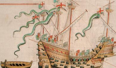
When the 58,000 tonne Caledon carried its cargo of South African fruit and wine into the Thames estuary on 6th November 2013, a new chapter in the port of London’s long history began. It was the first ship to berth at London Gateway, the massive container port built for DP World at Thurrock, in Essex. This is some 30 miles east of the ancient City where the first (rather more modest) port had been established some 2,000 years earlier. Londinium’s Roman harbour had waxed and waned between AD50 and AD500, before a new Mid Saxon beach market subsequently developed to the west at Lundenwic, just off the Strand near Aldwych in c. AD 600. By AD 900, the entire Saxon settlement, complete with beach market, had relocated back to the site of the abandoned Roman city on the orders of King Alfred the Great. The open harbour was initially centred in the western half of the City, but once the first medieval timber bridge was built in c AD1000, the beach market was extended eastwards to the Billingsgate area. A period of expansion then saw the beach market transformed into a medieval merchant port by the 13th century, and by the end of the 14th century, the officials working in the new Custom House were kept busy cataloguing diverse cargoes brought to the City from all over Europe. It is this series of harbours that is described here, illuminated partially by documentary records, but especially by half a century of archaeological endeavour. Rather than describing a history of the port of London, it seems more appropriate to say PORTS of London, since the locations, vessels, cargoes and waterfront facilities differed as much as the prevalent languages, cultures and currencies.
LONDINIUM: the Roman port AD50-500
One of the earliest surviving contemporary references to Roman London is by Cornelius Tacitcus (cAD55-120), who wrote a brief description of a native uprising in AD 60 in the newly-occupied province of Britannia. Although the settlement was not described as a high-ranking colonia, it was nevertheless regarded as “an important centre for businessmen and merchandise”. But there is little else in the meagre surviving documented history of the town to illuminate the development of that provincial port.
The archaeological evidence, by contrast, has revolutionised our understanding of the settlement: indeed, the associated harbour excavation programme conducted by archaeologists in the modern-day City was one of the largest such projects of its type. Londinium lies at the head of the sinuous Thames estuary just 50 miles from the North Sea. The river rises well to the west of London, passing through an agriculturally-rich valley in the temperate south-eastern corner of the province. The town thus enjoyed the benefit of an extensive and fertile hinterland, fresh water, fish stocks, a long navigable tidal waterway affording direct access to the sea, the channel ports and the European mainland. The majority of the Roman town lies beneath the financial district known as ‘the City’, and was very much smaller than the present day 32-borough conurbation of Greater London. Our knowledge of the port’s history has been built up piecemeal, primarily the result of an intensive programme of rescue excavations conducted principally by archaeologists from the Museum of London. That systematic programme of waterfront excavations began in earnest in the early 1970s, but was preceded by an earlier generation of nautical archaeological investigations, beginning in February 1910 with the discovery of the first of three Roman ships. This was uncovered during the building of County Hall on a riverside site in Lambeth. The late 3rd-century vessel was about 20m long with a beam of 3m. The other two finds were the rather smaller New Guy’s House vessel discovered in 1958 and the larger Blackfriars ship excavated in 1962-3.
Thus by the end of the 1960s, Londinium had three Roman ships, but little evidence of the harbour that accommodated them. However, this was precisely the period in which the adoption of containerisation led to the closure of the London’s enclosed docks from 1967 to 1981. A modern container port needs a deep-water berth and acres of open space. By contrast, the Thames in central London was flanked by tall stacks of warehouses built not only in the enclosed docks to the east and south of the City, but even in the City reach itself. The advent of containerisation rendered these warehouses obsolete overnight, and a wholesale demolition programme began, both in the City of London and on the southern shore in Southwark. In their place a new generation of office buildings and other facilities were built, as London changed from working port to a financial centre.
The major urban redevelopment programme that accompanied this transformation coincided with the establishment of London’s first full-time professional archaeological units. From 1971 onwards, rescue excavations were regularly undertaken as the redevelopments progressed, all along the London waterfront. It was discovered that the river bank in the first century AD did not lie below the modern quayside, but 100m inland, just north of Thames Street. Many well-reserved sections of heavily-built Roman timber quays structures were uncovered. Some survived up to their full height of over 2m, a series of squared baulks of oak, up to 600mm by 400mm in cross-section, with timbers up to 9m long, stacked one upon the other, up to six tiers high. They usually revetted an infill of gravel and clays thrown in behind the timbers, up to the level of the working surface of the quay. Many of the timber structures have been closely dated by dendrochronological analysis from the 1st to the 3rd centuries, working with a master oak chronology for Roman London running from 252BC to AD 294.
It now seems that the first really significant attempt at establishing a major harbour facility here was not in c AD50, when the first settlement was founded, but in c AD62-3. These were in those fraught years immediately following a devastating native rebellion that all but ended the Roman occupation less than 20 years after it had begun. Excavations up on the hillside near Fenchurch Street suggests part of the settlement had belatedly been defended by a temporary fortification to protect it from any further native insurrections. Contemporary with it, but on the waterfront to the south, the first major timber quay was recorded below Regis House, revealing warehouse buildings as well as a well-preserved section of a mid-first-century wooden quay. Some of the timbers were taken from military stock piles, since the end-grain has been branded with stamps, one of which may have read TRAECAVG, perhaps attesting to the presence of a Thracian unit. Other evidence for military involvement in the quay’s construction, apart from its scale and style, include fragments of armour and part of a leather tent. Thus it can be surmised that London’s first major harbour facility was built by the state (rather than by private merchants) representing a genuine desire on the part of the authorities to provide the essential infrastructure to kick-start the shattered economy of the province.
On the site immediately to the east, a large open-work landing stage was erected in c AD70, perhaps representing a ferry terminal before the bridge was constructed. This energetic programme of harbour development continued unabated into the 3rd century, with a timber bridge built by AD85-90 as well as a succession of timber quay structures, each one set further out into the river. The sequence also extended to the east of the initial bridgehead focus, and west, first as far as the mouth of the Walbrook stream (a tributary of the Thames), and then, by AD 200, beyond it.
Londinium and the Classis Britannica
Unlike other provinces with a longer history of contact with Rome, Britannia simply did not have an indigenous fleet of merchant vessels. If the new province was to prosper, then such a fleet would have to be built to support not just the military machine but also the nascent programme of urbanisation. A country with no tradition of monumental masonry building, for example, would clearly have to import or develop all the requisite technology, expertise and facilities to start such a programme as well as providing a fleet of stone-carrying barges to transport the required stone tile and timber in the quantity required to transform the province. It is suggested here that the Roman fleet, the Classis Britannica, facilitated that particular role.
The Classis Britannica fleet was raised in AD 43 to launch the Roman invasion of Britain. Bases have been excavated at Boulogne and also at Dover, where the occupation of its fort is dated from the early 2nd to the early 3rd century, precisely the same date range as the Cripplegate Fort built in Londinium. In addition to its overtly military role transporting the legions serving the provincial governor, the Classis Britannica also played a major role in the economic development of the province. It was heavily involved with iron-working in the Weald, stone quarrying and tile industries and, crucially for an island province, provided a continuous shuttle service between Boulogne and Dover. It was this through this umbilical link with the rest of the empire that much of the exports and imports to and from Londinium passed. The fleet would have worked closely with the procuratorial office in Britannia: Maenius Agrippa, who was Prefect of the Fleet in c AD130, is also recorded as serving as the provincial procurator, for example. The port would suffer dreadfully once the fleet was disbanded in the late 3rd century.
Traffic and Trade
The archaeological evidence for the cargoes handled in Londinium when the port was thriving include commodities such wine, fish sauce and olive oil, all of which were transported in amphorae, a most common find in London. These containers have been sourced to France, Spain, Italy, North Africa and the East Mediterranean, representing the range of contacts this provincial port engaged with directly or indirectly: most cargoes arrived on the Thames having been transhipped several times through the extensive Roman entrepot network.
Another major import was tableware: the London waterfront assemblages include large quantities of broken but unused Samian ware from Gaul, representing breakages in transit or warehouse clearance of old stock. A remarkable 2nd-century inscription excavated from a London temple, and has been translated by Roger Tomlin, from Oxford University. It names a merchant of London (moritix Londiniensi) called Tiberinius Celerianus, a citizen of the Bellovaci, near Beauvis in northern France, but represents a clear personal and commercial link between the provinces of Gaul and the Britannia.
Exports included lead ingots representing the mineral wealth of the province: three stamped examples were recovered from an excavation of a waterfront warehouse. There would also presumably have been wool and textiles, as well as the items noted by Strabo, grain, hunting-dogs and slaves. Although the latter usually make little impression on the archaeological record, a writing tablet from the excavations at No 1 Poultry actually records the sale of a slave girl, Fortunata, for 600 denarii (two year’s salary for a legionary) in about AD 100.
Thus a busy waterfront market can be envisaged, at least in the 1st to early 3rd century, focussed on the riverside horrea. These were open-fronted, timber-floored, and set 5m behind the quay front. The plan-form of such waterfront buildings is well-known from other Roman harbour sites. Such buildings may have served a similar function to latter-day transit sheds. However, by the 4th century, solid partition walls subdivide the horrea range; each individual room developed as a separate unit, and some had hearths in them. This evidence strongly suggests that the horrea buildings were no longer used for bulk storage but have been converted into residential units. This was precisely the same fate that befell the obsolete warehouses of the 19th-century port: as London’s great Victorian docks closed, so the last surviving warehouses were converted into apartment buildings. Thus the dramatic change of use of the ancient horrea provides evidence for the demise of the Roman harbour. Indeed, even the timber quays were neither extended or even maintained, but had been largely dismantled by the 4th century, following the construction of a riverside defensive wall built along the Thames waterfront, effectively dividing the port from the river.
Study of the Roman Thames shows that its width, depth, salinity and tidal range have all changed markedly since the 1st century. Today, the Thames is a tidal canal, restricted to a width in central London of some 250m between solid river walls on both banks. In the Roman period, the situation was very different: although the tidal range was only just over 1m, the difference between the riparian topography at low tide and high tide was particularly dramatic on the south bank. Here, at high tide, low islands just projected above the water, with a river up to 1km wide to the east. At low tide, the river retreated to reveal an inhospitable expanse of marshes and mudflats, in contrast to the steeply rising dry hillside on the north bank. But research now shows that the level of the river relative to the land actually fell in the late Roman period, a situation quite at odds with the long-term trend. Indeed, it seems that in late Roman London the tidal head (often regarded as the natural limit for sea-going navigation) must have drifted further east, taking with it, the primary rationale for the settlement of London to serve as a port.
LUNDENWIC: the mid-Saxon port 600-900
In the great upheavals that accompanied the dissolution of the Roman Empire on its northern frontier, Londinium was abandoned in the wake of a wave of Saxon invasions by AD 500. When the later Saxon port of Lundenwic was established in the 7th century AD, it was on a different site, two miles to the west of the deserted Roman town. This initiative differed from the old Roman harbour in almost every particular. It was developed by the war-like Anglo-Saxons, the Germanic ‘barbarians’ who crossed the North Sea to over-run the province, bringing with them a new language (English), new religions, new culture and a new economic system. This was the age of the ‘beach-market’ when shallow-draft vessels would be pulled up onto the foreshore and products sold to the townsfolk directly from the ships. There was no need for deep-water quays, warehouses or middlemen, in a period when more people owned a boat than a horse and cart. That system would serve the Saxon port for some 500 years before later Medieval London developed the social, economic and physical infrastructure of a major merchant port once more. But this time it was more individual enterprise rather than state sponsorship that underpinned the developments.
The mid-Saxon port of Lundenwic lasted almost as long as its more famous predecessor, but is rather less well-known. The broad outlines of the political context in which this new port grew up can be suggested by consideration of such scant documentary records as survive. There is a last reference to Roman Londinium in the Anglo –Saxon Chronicle for c. AD 456, recording that invading Saxon warriors fought against the Britons, killing 4,000, while the rest fled to London. The archaeological evidence suggests that the City walls did not save them, since the settlement was subsequently abandoned. The next relevant documentary reference was compiled in the early 8th century by the Venerable Bede, a Northumbrian monk. In his Ecclesiastical History of the English Nation he describes London as a “mart of many nations resorting to it by land and sea” and refers to the founding of St Paul’s minster church. Other buildings are mentioned in royal decrees of 685, referring to the King’s hall in that town, where the King’s reeve bore witness to legal transactions.
Such brief incidental documentary references describe a town transformed in the 7th century, but where was it? The answer was one of the most remarkable discoveries of the late 20th century, for the lost Saxon town did not lie directly over the abandoned Roman site of Londinium as many had imagined, but lay to the west of the deserted walled site, in the area we now know as Covent Garden. This missing chapter in the capital’s history was revealed in 1985, following excavations on the Jubilee Market site. Work elsewhere in the area has begun to define the limits of the town, which stretched from Shorts Gardens to the Thames, and from Trafalgar Square to the Royal Opera House. There were also outlying farms, such as the one found beneath the Treasury in Downing Street, between the main settlement and the ancient church of St Peter’s on Thorney Island, the ‘West Minster’.
The new town that succeeded Londinium therefore had a new site, a new language and a new culture: it even had a new name, Lundenwic, of which the ‘wic’ element means ‘market’ town’. Its seems that this settlement incorporated a mixture of farmers and small holders, together with craftworkers dealing in bone, antler, metal or cloth as well as fisherman and traders on the riverbank. In keeping with contemporary practice in northern Europe, transactions of riverbourne trade would have taken place on the waterfront, actually from boats pulled up on the foreshore. Initially the system needs no shops, stalls or warehouses and no major cargo-handling facilities. It has its origins primarily in the need for a simple neighbourhood exchange centre, rather than solely upon long-distance trade networks. A variety of small boats laden with local produce would be commonplace, a riverside version of a street market, in an age when more people owned small boats than kept a horse and cart. Such markets acted as a focus for both local and long-distance trade, barter and exchange.
The specific location of the beach market would be clearly defined. The officially-recognised site was known by the term ripa emptoralis (trading shore). A grant of land in Surrey made by king Frithuwald in 672 mentions that the estate on the south bank of the Thames lay opposite “the port of London where ships come to land”. A toll could be charged on the boats moored there navium stationes, the equivalent of paying rent for a market stall. Tolls would be collected for whoever owned the rights for that particular site, usually the king. The tolls were collected by the port-reeves, officials who are mentioned in the plural in a document dated to 734-5 in a grant by King Athebald of Mercia.
Study of such documentary matter as has survived have therefore built a broad framework upon which a general chronology of the Saxon port can be built. But this can be extended by consideration of the material evidence, recovered from the excavation programme. Pottery studies have already identified two distinct phases in the port’s development. The first, 630-750, suggests rather limited horizons, since the most common pottery found in Lundenwic is a locally-made ware, representing a modest hinterland for the first phase of the port’s development. Presumably most of its grain, meat, fuel, wool, hay and timber were derived from the immediate locale, which implies a community in which farming in all its forms was still a prime concern. Next to no imported pottery is associated with this phase, although the presence of freshwater and marine fish species shows that river and coastal traffic was accommodated there.
Significantly, a greater range of pottery is found in later levels at Lundenwic. This represents wider regional and national roles in the late 8th and 9th centuries that presumably developed with the size of its population. The important link to the east coast trade network is represented by Ipswich ware, imported in quantity from East Anglia, found alongside pottery from Kent and the Mercian midlands. This noticeable increase in the size of its English hinterland is mirrored by evidence for increasing contact with contemporary ports such as Dorestad in the Netherlands and Quentovic, in the Pas de Calais. The presence of continental pottery from the later 7th century onwards suggests that, after a generation or so, Lundenwic had established itself sufficiently to attract the attention of continental traders, handling quernstones, wine and various luxury goods. In return, Lundenwic may have been exporting wool or cloth: excavations in all parts of the settlement produced plenty of evidence of clothworking, including spindle whorls and over 500 loomweights- as well as many sheep bones.
The town had a mint by the mid 7thcentury, since gold coins bearing its name have been found elsewhere in England. The silver sceatta series B coin, also probably minted in London, have a wider distribution, extending from south-west France to Jutland. Lundenwic’s trading contacts therefore extended in the 8th century and beyond, as the recovery of continental pottery also shows. The settlement itself also expanded, as admirably exemplified on the Royal Opera House site, the largest controlled excavation investigated in Lundenwic.
As for the open harbour, there have been archaeological investigations between the Strand and the Thames. One such was below York Buildings in 1988, behind Victoria Embankment gardens. Over 100m landwards of the present river wall, sandy foreshore deposits were revealed, over which a low brushwood and rubble embankment had been laid, retained by a pile and plank revetment. Dendrochronological analysis of the oak planks showed they were cut from trees felled between AD 670-690. The upper surface of the brushwood mat was laid at +0.8m above present sea-level. This modest excavation therefore established the line of the 7th-century waterfront and the level of the contemporary river. It also dated harbour developments to the precise decades in which Frithuwald’s charter of 672 records the earliest unambiguous documentary reference to the Saxon beach market.
Fishbones recovered from Lundenwic include freshwater species (eel, pike, roach) as well as marine species (cod, haddock, herring, whiting, bass, plaice, flounder) together with oysters from the estuary and even a vertebra from a Longfin Pilot Whale. The thriving coastal and inshore fishing industry represented was not just of dietary importance: fishermen would have provided the craft, contacts and seamanship required to conduct trade in other commodities. The development of medieval ports and trade often grew alongside a strong fishing industry, and Lundenwic was no exception to that rule.
But in 801, 841, 852 and 871 Lundenwic’s prosperity attracted the unwelcome attentions of Viking raiders. Much of Europe suffered such violence, destroying lives, towns and trade. The London mint went out of production from 851 for over a decade, while the hoards of silver pennies buried in desperation by Londoners in anticipation of such attacks are a poignant reminder of those savage times: no Saxons survived to recover them. But in AD 878 the Anglo Saxon Chronicle records that Alfred, King of Wessex “overthrew the pagans with a great carnage" and recovered London from the Danes. The plans that the great warlord then put into action had a profound effect on the subsequent history of the harbour, the town and the nation. The defenceless old ‘wic’ (Aldwych) had to be abandoned if London was to have a future. So, in AD 886, Alfred moved the entire settlement back inside the old Roman walls, and “rebuilt London in a splendid manner”.
Late Saxon Port: AD900-1000
The more defensible new town of Lundenburgh was laid out in the last decades of the 9th century over the fields that covered the abandoned settlement of Londinium. Its harbour comprised a long, low earthern, gravel and timber embankment constructed over the open foreshore, directly abutting the much repaired Roman riverside wall. Access to it (and the beach market it accommodated at low tide) was restricted to gates cut through the wall. These embankments provided a dry standing at most states of the tide, at the foot of which the contemporary shallow-draft vessels could be hauled up out of the water when required. Initially, these embankments were laid out in the western half of the waterfront, around Queenhithe and the mouth of the Walbrook (near Cannon Street station).
Saxo-Norman Port: 1000-1200
However, a fresh wave of sea-bourne invasions by Viking raiders hit the country in the late 10thcentury, and drastic measures had to be taken to protect the City. One such initiative saw the construction of London’s first medieval timber bridge, built as defence to obstruct the passage of raiding war fleets. Fragmentary evidence for the southern abutment of this structure was recorded in 1984 on the Southwark shore, and its construction dated to this troubled period, between c. AD 980 and 1000, i.e. in the reign of the Ethelred-the-Unready.
London initially held out against these ruthless invaders, but finally fell in 1016, as England was forcibly subsumed into Canute’s expanding empire, where it remained until 1042. But the construction of the bridge had an unanticipated impact on the town: although built to deter raiders in times of war, in times of peace, it also impeded the passage of traders sailing in from the North Sea. The bridge now became the artificial but effective limit of navigation for ships, and thus the central hub for seabourne traffic below it, riverbourne traffic above it, and road traffic over it. This provided London with a geographic and economic advantage over all other towns in south-east England, an advantage that Medieval London exploited to the full. Its prosperity and population expanded dramatically on the back of the bridge, but, once again, the increased wealth attracted the attention of yet more invaders.
The brutal Normans conquered the country following the infamous Battle of Hastings in 1066. Their occupation of the City and their greedy tax regime impacted on all aspects of the social and economic life of Londoners, now obliged to service the demanding architectural ambitions and consumer preferences of their new masters. Nevertheless, London fostered an independent and entrepreneurial spirit: as long as it made money, the monarch granted it a measure of self-governance. The king was unwilling to kill its golden goose. It is within this context that the next change in the port and harbour should be seen: the transformation of a modest beach-market into a merchant port.
A port transformed: 1200-1500
A series of related features that have been archaeologically investigated and dated show that, one by one, the characteristic elements of the beach-market model were displaced or replaced, mostly in the 12th century, and certainly be the 13th. The removal of the old Roman waterfront wall, partially by aggressive tidal erosion, and then by deliberate intent, opened up the waterfront for the first time since the 3rd century. The communal Saxon embankments now gave way to individual waterfront properties, with their own private river stairs: each private property was now bounded by its own riverfront revetment, initially timber-built, but later faced with masonry. From the 12th century onwards, the occupiers of these discrete narrow waterfront property plots extended them riverwards, more or less as they chose, to gain more ground at the expense of the river. On this newly-won land, London’s first custom-built waterfront warehouses appear, the earliest on the land owned by the Hanseatic merchants and on adjacent sites in Vintry ward: the physical embodiment of the arrival of middlemen and merchants and the development of formal retail and wholesale markets. This new social class are also represented in the material record by the firs appearance of tally sticks, merchant seals, jettons, weights and balances, for example.
The expansion of the cash economy necessarily accompanied these fundamental changes. From a world in which the silver penny was universal common unit of currency, by 1279 small change included the minting of silver half-pennies and farthings, and later groats and half-groats (4d and 2d). By 1344, both gold and silver coins were in circulation, with the introduction of gold nobles (6s 8d). The widening range and increasing proportion of imported pottery found in London in the 12th to the 15th shows a market hinterland expanding from Normandy and the Baltic countries to include Bordeaux, Germany, and Spain and to Venice, represented by Murano glass.
The design and size of ships reflects these changes, as nautical archaeological research across Europe demonstrates. In AD100, a typical cargo carrier would weigh in at 20 tons, by AD1100, this had increased to 60 tons, but by AD1200, 100 tons was not considered unusual. Shipwrights were now building specialised bulk cargo carriers, for a dedicated merchant class.
These consistent trends represented by the material evidence can now be viewed alongside the richer documentary sources for later Medieval London, not least the market regulations in the Liber Albus, and ultimately in the Port Books listing the tax on imports and exports, as catalogued by the staff in the new Custom House, built in 1380s, where one Geoffrey Chaucer once worked. And some of the port-related place names he would have known still survive: Vintry, Garlickhithe, Timberhithe, Wool Quay, Galley Quay, the Ropery, Hay Wharf, Salt Wharf, Fish Street Hill and Friday Street.
By the end of the 15th century, then, in spite of invasions, the Hundred Years War with France, outbreaks of plague, and damaging civil wars, the port was prospering as never before. The economic and mercantile foundations the City had laid would prove invaluable when a new century opened up a New World and the possibility, for better or for worse, of a truly global expansion.
© Gustav Milne, 2016
FURTHER READING
Brigham, T, 1990 'The waterfront in Late Roman London', Britannia 21, 99-183
Cobb, H, 1990 Overseas Trade of London; Exchequer Customs Accounts, 1480-81,
London Record Society 27
Marsden, P 1994 Ships of the Port of London: 1st to 11th centuries AD, English Heritage Arch Rep 3
Marsden, P 1996 Ships of the Port of London: 12th to 17th centuries AD, English Heritage Arch Rep 6
Milne, G, 1985 (rev ed 1993) The Port of Roman London
Milne 1995 Roman London: urban archaeology in the nation’s capital
Milne, G, 2000 ‘A Roman provincial fleet: the Classis Britannica reconsidered’,
in G Oliver et al (eds) The Sea in Antiquity, BAR 899, 127-131
Milne, G, 2003 The Port of Medieval London
Watson, B, Brigham, T & Dyson, T, 2001 London Bridge: 2000 years of a river crossing
Part of:
This event was on Mon, 17 Oct 2016

Support Gresham
Gresham College has offered an outstanding education to the public free of charge for over 400 years. Today, Gresham plays an important role in fostering a love of learning and a greater understanding of ourselves and the world around us. Your donation will help to widen our reach and to broaden our audience, allowing more people to benefit from a high-quality education from some of the brightest minds.