Login
Login
The Natural Environment of Tudor London

Share

- Details
- Text
- Audio
- Downloads
- Extra Reading
Tudor London is variously reported as a squalid seething mass of humanity choking on its own filth and fumes, and as a delightful garden where babbling brooks and sweet flowers delighted the senses of people such as Elizabeth I, Shakespeare and Erasmus.
Drawing on evidence from contemporary maps, paintings and writings, and modern environmental science, the lecture will offer a 'virtual' walk around the City with Sir Thomas Gresham, evaluating these different perspectives on the City’s air, water, soil and wildlife.
Download Text

10 April 2019
The Natural Environment of Tudor London
Professor Carolyn Roberts
I could have chosen any number of individuals to act as a guide through Tudor London, but we know that Sir Thomas was an intelligent man with an eye for curiosity and an understanding of the broad sweep of history too - and that's a sound basis, I think, for a companionable walk.
I'm not a historian, so I should own up to that. I'm an environmental scientist, so some of the history, I've had to get to grips with myself.
Strictly speaking the medieval period ended and the Tudor period began on the 22nd of August 1485, when Henry Tudor defeated Richard III at Bosworth and I should add I come from Leicester, so that's of some interest to me too.
This prompted some immediate changes in the way things were done, for example the switch to the use of English instead of Latin in courts. But the impact of the transition was arguably very limited until the dissolution or the closing of the monasteries by Henry VIII in the 1540s. That created not only enormous social upheaval but massive changes in the shape and functioning of the City of London, which impacted dramatically on its natural history: its air, soil, water, and ecology.
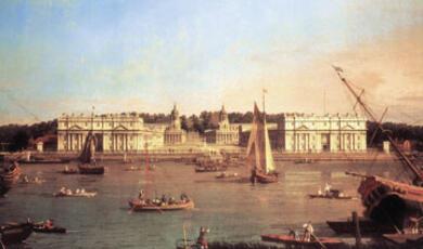
My lecture tonight is only going to scratch the metaphorical surface of the ground. But I have provided a bibliography which will be available on the internet for those of you who would like to know more. London is what we might call a ‘palimpsest’, a ‘palimpsest’ is a montage of old and new - the new being written over the old in so many ways as we see here in the city and here in the old valley of the Fleet River viewed from Holborn Viaduct. The Fleet or the Holborn River was navigable to this point in the late medieval period, which is rather extraordinary when you look at it now.
The massive spread in the modern city, nine million inhabitants, can be seen here in this extraordinary 2018 panorama. It's 24 hours in London shot during 2018. That's London in the 21st century. [1] But we need to go back to an earlier panorama, which is pretty close to the time of Sir Thomas Gresham: 1616. The panorama of London by Claes Visscher, testifies to change in the city if not progress. That's the 1660 view but of course the sight of London was not a wilderness before the 16th century and we need to understand quite a lot more about that to grasp environmental inheritance.
The Tudor City straddled three low gravelly hills: Ludgate Hill, Corn Hill, and Tower Hill and a great English river, the Thames. Two millennia earlier the local Celtic population had hunted, farmed and lived here using Iron Age technology. The hills provided a very convenient foundation for settlement close to the Thames Estuary with fresh water available from the Walbrook Stream which ran between them. Much of the area was forested so semi-permanent settlement required clearings and the suffix in place names 'dun' denotes circular defensive earthworks for example at Croydon, Hillingdon, and perhaps London itself.
After some centuries there was another invasion: from Roman times onwards, about AD 43, Londinium grew into a much more substantial settlement of perhaps sixty thousand people living where the gravel allowed offloading of the cargo from trading vessels. By then of course native trees such as Oak, Oak Birch, Beech and Ash had been cut and burnt over a wide area and farms spread out around this new city. There were stone and brick buildings housing the administration shops and offices and a wooden bridge had replaced the shallow Thames Ford between Lambeth and Westminster.
However, despite the construction of a huge stone wall to repel further invaders eventually it all became too trying for the Romans. After about AD 410 these European tax collectors and legions consequently either departed for sunnier climates or they went native by setting up shop with the locals. And plants like Rose Bay, Willow Herb. Ragwort fleabane and grass sprouted in the streets again, recolonizing the rubble.
The Anglo-Saxon chronicles, of around AD 456, say that the Romano-British descendants were then merely squatting amongst the ruins of Londinium. Whereas further up the Thames at Lundenwic, west of the River Fleet near Blackfriars, a few hundred very energetic Anglo-Saxon incomers were trading from a major port at Charing Cross. There, substantial timber or ‘wattle & daub’ buildings were quite extensive from north of the Strand to Oxford Street, and from Covent Garden across to Trafalgar Square built on the formerly arable land of the Roman farmers. And by AD 600s, the venerable bede referred to a bustling emporium of eight thousand people. Remember though that in Roman times there had been sixty thousand people living there. Eight thousand people along with metal, pottery, and textile workshops and a lot of money, these Saxon buildings were also likely to have been surrounded by fields and secondary forest and further west at Westminster, the river Tyburn flowed down from the heathland of Hampstead into the marshy Thames, through two branches with a raised wooden causeway linking the island between them to the mainland, this was a much more wild area with deer, wild bulls and boar, bears, wolves, and beavers - the target for hunters. And you would have been able to hear marsh birds and bitterns calling amongst the willow and the reeds.
In the eighth century we should report that the Saxon luck ran out and there were a series of very savage summer attacks by the Vikings, who from about AD 865 decided not to go home to Scandinavia at all. The Saxon King Alfred tried to move his commercial hub back inside the Roman walls, he had been off somewhere on the western side. Despite those walls being in ruins they were easier to defend and so Ludenberg, as it was then, became a border town occupying about a quarter of the old roman city in a grid of streets between the Walbrook and St Paul's and from the river north to Cheapside. Families occupied small wooden thatched huts surrounded by plots in which they gardened and kept animals, particularly pigs and sheep and goats. Much of the land within the walls remained as abandoned fields, but the dwellings gradually spread back eastwards across the fields to what would become the site of the Tower of London and Billingsgate.
In about AD 1000 there was a millennium project, as it were, which saw the construction of a new timber bridge and the Saxon port moved further downstream initially to what became Queenhithe. So, this progressively easterly move towards the deeper estuarine waters has continued till the present day. Unfortunately, London's history continued to be marred by violence - despite various treaties, Viking attacks, fire, squabbles, sieges and pitched battles, which damaged the infrastructure, Olaf Haraldsson taught the Londoners a particularly sharp lesson in AD 1014 by pulling down their new bridge. The point here is that repeated rounds of building and demolition razed the land surface by a metre or more in places, with the vegetation becoming progressively more degraded and the loss of most of the large trees.
Not everything was a disaster, the Saxon inhabitants were somehow persuaded to redouble their efforts under king Edward: he turned the small timber monastery on Thorney Island in the Westminster marshes into the stone monument that is now Westminster Abbey, but he did concurrently destroy the pristine, marsh environment - one suspects today that it wouldn't have had planning permission on habitat conservation grounds. However, now of course we have two elements of the city, the area inside the former Roman walls and an outpost at Westminster to the west separated by land that was not built up but retained some of its rural character, that was to be occupied in due course by smart new villas.
Over the following 500 years, there were hurricanes, floods, fires, and plagues and reconstructions. The Normans built the Tower of London and the Guildhall and stone or tiled houses also started to emerge amongst the highly combustible ‘wattle & daub’ cottages. London Bridge was rebuilt in stone, at considerable loss of life, but the locals couldn't keep away from the carpentry and they soon covered it with wooden shops, houses and privies, about which we'll hear more later. The point here is London had started its journey to become the dominant city for Britain and an area where the natural environment was rather difficult to discern within the city walls.
By the end of the 15th century the city was home to about fifty to sixty thousand people again, from a national total of two and a half million who mostly lived in small villages. London at that time was smallish in a world context; Beijing, Agra, Istanbul, and others are thought to be much larger cities at this time but it was four times the size of Norwich and much bigger than York, Bristol, Salisbury or Exeter, plus it had begun to spread outside the Roman walls.
I want to draw your attention to these layers of rock underneath the city - this is near the Blackwall tunnel. At the top you can see the extent of the made ground and it is very significant, huge thickness of what today we would call the Anthropocene period: ground made up of rubble of buildings and so on, not perhaps a very fruitful geological substrate for the growth of plants. So by 1600 some two hundred thousand men women and children were squeezed into an area in and immediately around the old Roman settlement with a lot of their livestock and pets. So, what's apparent is that London was gradually taking a background in Tudor times. This map summarizes this pattern: here we see a map of London in about 1370 with some later additions. The problem with this Gough map is we can't see very much on it - the area in the middle is London but it is obviously not a very good depiction.
This one of course and some of the others too, they do again show the distinction between the built-up area and the fields beyond, but the evidence of natural vegetation, wildlife or other environmental matters is very sparse. Cartographers would draw on the work of early maps by other cartographers, so you often get inconsistencies in what appears to be the date and growth of the city. John Speed's map was copied from John Norden's map and Christopher Saxton's map. But Speed's map nevertheless shows villages such as Islington, Kentish Town, Hampstead and the park at what was called Mary bone, but they're all very weak on topography. The Hollar Map does though if you look very carefully, you can see in some of the squares formal garden patterns starting to emerge.
As the city grew there was a drift, of course in the areas beyond the city boundary or the built-up areas, from arable cultivation to livestock, from corn to pasture around the Tudor suburbs of places like Stepney, Harringay, Hackney, Knightsbridge and Bromley. Perhaps of course, the climate was becoming a little colder and wetter. And there were still some ancient woodlands but despite some legal protection, those were being nibbled away by the gathering of firewood and the grazing of animals.
Some suburban areas were being developed as brick fields and lime kilns - for example, in Whitechapel and Spitalfields - because that was more lucrative than farming. And the associated fumes and the removal of topsoil are lampooned in 19th century images. This 19th century image shows London going out of town or the ‘March of Bricks and Mortar’. Published in the 19th century, you can see the bricks spewing out into new buildings and the haystacks running away. It would have been just the same in Tudor times.
Now here I've just tried to summarize that growth in comparison with the modern extent of London. You can see Bromley, Mitcham, Hounslow, Harrow, Edgeware and London, which looks very small. You can see the Roman city, the medieval city a little bit beyond it, and the 1590 Tudor city, which we're looking at in particular. The city is spreading out along major routes in all directions.
This unattributed sixteenth century map, drawn up about 1505, shows you the nature of that inner city: packed densely with small houses, perhaps with only tiny yards behind them. You can also see the Fleet River open to the air running into the Thames and some other open spaces particularly around St Paul’s churchyard. You can see some trees: deciduous, coniferous and orchard. You must look very carefully, but if you find Blackfriars, you can see representations of these trees.
So what I would ask you at this point is where is the natural environment of Tudor London? Was it in the maps and pictures and writings of the time? Do we think the city is just a little scar on the surface of a primarily natural environment? Or does it reflect wholesale change in the wildlife and plants, the soils, waters, and air of the lower Thames? Now in our minds, we may hold a view of city squalor and stench, but some contemporary writings suggest otherwise.
This image shows a choir singing with musical notes but the only natural environment that is visible is the sky. There are some birds carefully drawn in and a dog, perhaps you might imagine that's Thomas Gresham having a go at it.
The quotes are all slightly before the period we are interested in, however, Domenico Mancini was a Parisian scholar who visited London in 1482 and he described it as a 'royal city'. Another writer said it was the 'sovereign of the flour [sic] of cities seem layest in sight'. Vaclev Schasek said 'elegant gardens planted with various trees and flowers, which are not found in other countries'. We have suggestions from very famous topographer John Stow in his survey of London, writing about the Thames saying there were 'snow white swans' fishing for 'needful meat' in the Thames. George Turberville, a little bit earlier in our period of interest, the 'silver streaming Thames whose rutty bank, the which his River hems was painted all with variable flowers...'. Thomas Platter said, 'the banks of this river are wooded and gay with pleasant Hamlet's and homesteads', he was talking about the bit downstream. A Venetian visitor who should of course have had a good knowledge of the water environment, described London as 'pleasant and delightful' but also he says the streets 'were so badly paved that they get wet at the slightest quantity of water' and there is 'a vast amount of evil-smelling mud, which doesn't disappear quickly but lasts a long time, in fact nearly the whole year round'.
So stinking mud was not the only environmental problem emerging in Tudor, London; as we'll see when we start our walk around the city, but before we sally forth, I'll just retell a little anecdote: in 1635 Thomas Parr, who was a labourer from Shropshire, he was said to be a hundred and fifty-two years old and he was presented to the king and a few weeks later he was brought from Shropshire to London but Old Parr, as he was known as, was dead soon after. Apparently not because of his great antiquity but in the opinion of a set of learned doctors, including William Harvey who pioneered blood circulation, he was dead because of a change in the non-naturals and specifically London's air. Now according to Harvey, Parr was a very robust and muscular man who had worked as a labourer until he was a hundred and thirty and maintained an active sex life until he was over a hundred. The poor-quality London air had done him in. So Harvey's view was this a city, whose grand characteristic is an 'immense concourse of men and animals where ditches abound and filth and offal lay scattered about to say nothing of the smoke engendered by the general use of sulphurous coal as a fuel had suffocated him'. Lest you think that this is an imaginary story, Parr is actually buried alongside Chaucer and Dickens as well other eminent people in Poets Corner in the south transept of Westminster Abbey. I don't know whether he was a hundred and fifty-two, I think that's a bit unlikely, but that the story clearly illustrates the problems with the air of London.
Now let's turn to Sir Thomas Gresham. I want to take you on a journey through some of the city's different areas. In Christmas 1559 Sir Thomas Gresham, who was the financier for Queen Elizabeth I and other earlier sovereigns, had been knighted for his services, but the following autumn he fell off his horse while riding in Antwerp and broke his leg, which troubled him for the rest of his life and made walking rather difficult despite administrations of a doctor who managed apparently to extract some of the bone fragments. I don't know how that was done; it sounds really painful. But with that calamity still to come let's imagine the newly ennobled Sir Thomas striding through London in the summer of 1560, perhaps reflecting on a number of things: perhaps reflecting on his hurried journey back to London to offer support to the recently enthroned Queen Elizabeth, reflecting on his long-suffering wife Anne who was planning their new townhouse in Bishopsgate, and unknown perhaps to her, his other wife and illegitimate child in Antwerp. So he clearly had a lot to mull over. It's worth noting too in the context of walking, that Sir Thomas had something of a shoe fetish, he apparently typically had four to six bespoke pairs made every year and in one year, he ordered five pairs for himself and 31 pairs for his employees and got a discount for ordering in bulk. Some of you will know that a new biography of Sir Thomas has been published by John Guy and it is a very good read.
To help us follow Sir Thomas’ journey I'm going to call on the Agas Map in particular (figure 14). This is the earliest detailed map of the City of London of which just three engraved printing plates survived, these are the copper plate maps of the late 1550s, one plate of which is here in the collection at this museum. Its derivative was originally printed from eight wood blocks and shows the city sometime between 1561 and 1571. There is an excellent website, which is run for some reason unknown by the University of Victoria in Canada[2], but it allows you to move around through the city on the Agas Map and look in more detail at the different streets and buildings. This map is a montage of all eight sheets, but it also tells us a lot about the natural environment of the city.
So Thomas is going to start his walk in Bishopsgate, close to where his new house was to be built in a few years’ time and he's going to head out beyond the city walls to Moorfield and Shoreditch. He doesn't yet imagine his grand house, but it would be splendid. This is the site on which it was due to be built. You can see Bishopsgate going up towards Shoreditch north. The house that was built doesn't actually look like this, so we assume this is a little sketch plan just before it was built. The house was in an ideal position close to the countryside. Thomas is going to walk up Bishopsgate and out into the fields to the north. That's the grand house that he was subsequently going to end up with. This actually was the first site of the original site of Gresham College, but it wasn't finished until 1566, after he had his injury his leg injury, so he wouldn't have seen that in the walk that we're going to take today.
But what he would have seen is what is shown in these images from the Agas map, they are really astonishing: he can see fields, hedges, isolated large trees and plenty of signs of life. If you look carefully you can see archers - there was a story about a woman walking in the field, I think it was in Spitalfields, who accidentally got shot through a hedge by some of the arches, so it wasn't actually really a safe place to walk. But there are people drying clothes presumably on the grass, wagons moving along the road, animals, cattle, sheep, and deer, larger houses spread out north of Bishopsgate and the old city wall, Moorgate. Bishopsgate has some fairly substantial properties starting to emerge north of the wall.
The main advantage for Thomas on his walk is to escape the noxious air that could build up in the congested areas closer to the city centre when there was little wind. Looking back there's a haze over the cottages almost impeding his view of St Paul's. On the windy hills to the north, we see the windmills are healthier. In Clerkenwell and Holborn and looking north you can also see some formal gardens and if you look carefully in some of the images you can see different kinds of trees including orchard trees.
The larger trees are almost certainly remnants of the forest that formerly occupied the area prior to the arrival of farming in Roman times. London's hinterland retained woodland well into the early modern period, for example at St John's Wood, which is only three miles north of Westminster. Hilary Miller, who has listed Tudor trees, points out that on none of the maps that she looked at did she see evidence of most of these trees. On many maps the species can only be inferred. However, if you look down the left-hand side of the next figure you can see the type of trees that would have been sitting just outside the city boundary.
Native trees and very early introductions, courtesy Hilary Miller, 2018
Oak: Quercus robur
Beech: Fagus sylvatica
Ash: Fraxinus excelsior
Hornbeam: Carpinus betulus
Common lime: Tilia x europaea/T. vulgaris
Small leaved lime: Tilia cordata
English elm: Ulmus procera
Wych elm: Ulmus glabra
Field maple: Acer campestre
Birch: Betula pubescens / B. verrucosa
Hawthorn: Crataegus monogyna
Willow: Salix alba / S. fragilis
White poplar: Populus alba
Black poplar: Populus nigra
Holly: Ilex aquifolium
Scots pine: Pinus sylvestris
Yew: Taxus baccata
Very widespread and frequent. Commonly pollarded. Major timber tree Native to S England. Extensive Chilterns trade to supply London’s firewood. Frequent – in some areas branches and leaves were cut for winter animal feed Native to S E England, notably Epping (pollarded), Hatfield & Hainault Forests. Possibly native or a very early introduction.
Native – usually a woodland tree.
Possibly a very early introduction. Very tall and formerly abundant
Native. More rounded silhouette than the English elm.
Small tree in woodlands and hedges.
Common
Small tree / shrub, common in hedges but also as small individual trees. Widespread and form large trees, usually in wet places.
Early introduction.
Native.
Evergreen, often an understorey in woodland
Scotland (further south in the post-glacial period). Planted elsewhere Native conifer. Not obvious on any of the early maps of London
Thomas perhaps is worried about the air quality as he looks south. An early author suggested that the smells of London came mainly from the idle poor, especially children and the elderly and that these people in particular should be paid small sums of money to clean the city or punished if they chose idleness. The stinking and loathsome vapours, apparently from their bodies and clothes, would then no longer trouble London's resident gentry. I'm not sure what Sir Thomas would have thought of that but it's certainly true that more of the stink came from chimneys, even on warm days from cooking. Some of it also came from brew houses, soap boilers, Lyme burners, and metal workshops, and a small amount at this date from coal. Most people cooked using wood or charcoal, which was brought in from the countryside areas around the city. Coal, particularly sea coal, was brought in from the northeast of England, and didn't become a major source of pollution until the later part of the century. Some twenty or thirty thousand tons of sea coal was brought in per year in the mid-16th century the tax records showed and the pressure to use sea coal, perhaps in the interests of protecting what was regarded as the commonwealth of the forests around the city was considerable. But it was the coal that was problematic and John Evelyn's 'Fumifugium', which wasn't published until 1661, refers to fulginess and filthy vapours. William Harrison, writing around this time, lamented the great sales yearly made of wood whereby an infinite quantity have been destroyed within these few years, so his concern was that the forests were being removed or the trees were being removed, which you can see here - this is Finsbury Field and Moorfields.
Queen Elizabeth's solution to the dark smoke problem was to jail 15 owners of brew houses, London's leading polluters who had started to use the coal. I would assume that wouldn't have been a very popular move. In January 1579 all the ale and beer brewers were summoned to the Worshipful Company of Brewers Hall by the commandments of the Lord Mayor and the Lord Chamberlain and told not to burn any coal while the Queen was living in Westminster. Despite protestations that there was no wood to be had in the winter, they were imprisoned and only released a few days later when they immediately went back to burning sea coal again. There was a key legal case a little later 1587 by a future Chief Justice Edward Koch who argued that, and this has very interesting resonances with planning applications today, he argued that light and sweet air were as necessary as pure and wholesome water, hence of course excessive smoke was illegal as a nuisance, the issue is though that it was the houses that remained the main source of the problem, with industry probably only responsible for about a quarter of the emissions.
Servants and others, who spent long hours cooking, would have been particularly susceptible to the smoke inside houses; fine particles, as I'm sure many of you know, are especially toxic because they get into your lungs and bloodstream and they create the haze characteristics of urban areas. Sulphur dioxide is also produced and that's very dangerous. Oddly there has been research on air pollution and some groups of researchers have estimated air pollution characteristics from 1125 through into the future suggest that by the end of the 16th century Sulphur dioxide, nitrogen dioxide, and PM10 (that's slightly more coarse particulates) were all dangerously high in the city, especially sulphur dioxide. In the Middle Ages it was thought that there were about five to seven micrograms per cubic meter of sulphur dioxide in the Middle Ages. In 1575, when Thomas was taking his walk, Sulphur dioxide levels probably reached twenty micrograms per cubic meter and they went on rising. Twenty micrograms per cubic meter, is the target for annual mean concentrations in today's legislation, routinely exceeded in Britain today. So particulate levels were about twenty micrograms per meter in the medieval city but forty by 1625. But western areas, and by western areas I mean still within the city wall, would have been cleaner because of the prevailing wind, but there was smog occasionally even then.
Now Thomas is now going to walk back down retracing his steps into the city heading south for London Bridge, he's going to take a boat to Westminster. But before that he's going to walk back through areas of the city that are much less salubrious: closely packed buildings had already created some hydrological changes, by 1543 some streets were required to be paved but a lot were not. The big problem was domestic rubbish: even from medieval times there had been laws forbidding people to throw rubbish into the yards and streets. Things like rotting fish, meat, and vegetables, and of course we know that is exactly what they did. Suburbs needed to be kept clear of mud and urine, according to Erasmus, and kept in better order to avoid epidemic diseases. There was animal waste from animals being walked to market and there were horses too. Some researchers have claimed that the ground in the city was not nearly as dirty as might be thought, complaints arose mainly from breaches of the law and they say that cleanliness was assumed to be important, not least because the smell of these rotting materials were thought to cause illnesses. They also say that commercial muck and household ash was being sold as a soil improver to market to gardeners outside the city and hence removed from the areas around the houses. However, in addition there were paid scavengers from 1528, a little before our time before Thomas Gresham's walk, there were official carts marked with the sign of a sword and a dong fork, and there were plenty of animal scavengers - there were dogs, kites, and pigs for example roaming around in the streets. However, other researchers have noted that there are so many repetitions of the nuisance complaints that they were very likely to reflect a significant problem; early Tudor cities were very dirty places by modern European standards.
This is the site where Gresham College is based today in Holborn and you can see the courtyard. This is likely to be a representation of the existing building. In fact, you can see here Fetter Lane and gardens behind it, Chancery Lane and wooded gardens, Holborn and interestingly a formal garden, not garden.
This is a procession along Cheapside of Edward VI going to his coronation. Looking across the river south towards Southwark and you can see open fields beyond the substantial trees of Southwark and the single line of houses.
Thomas would have passed very close to where his major project, the Royal Exchange, was to be built but it wasn't built until a score of years after the time we're talking about now.
This is a typical backyard, again this is a 19th century image but would have been very similar in Tudor times. Perhaps the yards might have been even smaller.
There were all sorts of problems with waste of all sorts then: disposal of dead bodies was likely to be a source of soil pollution with ammonia, hydrogen sulphide, fats, and greases leaking from corpses, not to mention the likelihood of pathogens entering the near surface environment. There were major burial sites at places like Smithfield, that were opened up after plagues and again in the mid-15th century. But there were graveyards around every church, and many were very full indeed so burial without coffins in shallow graves cannot but have generated offensive fluids which entered the soil and created contamination. We are also going to have contamination from proto-industrial workshops, acute toxic pollution from things like leatherworking, dyers, and fullers, all working with acids. In fact, at Houndsditch, outside the city wall, was a gun foundry that was polluting the ground with lead zinc cadmium and other metals. Now for comparative purposes this is a diagram taken from some of my own research some years ago in Africa, in Uganda. Uganda had a population of about forty thousand people but there were others, probably totalling nearer sixty thousand outside the administrative area, much of the population living without effective waste disposal systems leading them to throw waste and waste water onto the ground by their houses, unpaved minor roads and pit latrines. The population at that time and its weak technological base allows a comparison with Tudor London - I'm not suggesting that the characteristics of the people are similar to those of Tudor, London and of course, this is an area that even in 2005 had mobile phones and so on. But it did have a very inadequate drainage and waste disposal system. So what you see here is an area immediately around the built-up area of contaminated groundwater. I'll spare you the scientific details.
But if we go forward, I've done a rather crude diagram of what it would have been like in Tudor London. In the centre of London it would have been extremely contaminated, far more so than in Uganda, with all sorts of toxic contaminants leaking into the river and a small area on the south bank as well.
So, this sort of penumbra, if you like, stretching down but not quite reaching Westminster and then beyond that is reasonably safe. So, despite the activities of the scavengers Sir Thomas was probably picking his way carefully among the piles of excrement, rotting vegetation, and animal carcasses worried about his shoes.
The Thames is a great river, there is no doubt about that, It was described as “fair silver Thames clearest crystal flood” in a poem addressed to Queen Elizabeth I but in all likelihood the river was not crystal clear, even away from the banks by the time of Gresham's voyage. The river was very muddy at high tide and in flood - Harrison wrote in 1577, “You shall take haddock with your hand beneath the bridge as they float aloft upon the water whose eyes are so blinded with the thickness of that element that they can't see where to become”. Most of the feeder rivers were extensively polluted and people threw organic waste directly into the water. Eastcheap butchers threw slaughtered animals’ intestines into the river near Pudding Lane, despite this prohibition on industrial wastes, presumably at night when the chances of being caught were rather slight. We know that offal was supposed to be taken to the river front to be fed to the bears, but as Falstaff says in Shakespeare's ‘The Merry Wives of Windsor', "Have I lived to be carried in a basket like a barrow of butchers awful and to be thrown into the Thames?" i.e. they were polluting. There was a slaughterhouse close to Westminster Palace itself.
More importantly houses have privies draining directly into the river - more important than the offal - and chamber pots were routinely emptied into the river. Private privies were scattered about mainly near the Thames, pairs of houses often had their own cesspits filled by a shoot from the House of Easement or the House of Office. Those were only emptied occasionally, so household chamber pots were frequently emitted into the filthy streets. It wasn't supposed to be like that, the Merchant Tailor's School - the one established in 1561 in Suffolk Lane - had a school rule that said "unto their urine the scholars shall go to the places appointed them in the lane or street without the court while for other causes if need be they shall go to the waterside". By the 15th century there were a dozen public toilets in different places over the Fleet at Ludgate - known because Christ Hospital found babies in there at the Jake's. There was a longhouse, at Queenhithe, a common privy by the Thames: it seated 64 users simultaneously 32 men and 32 women, I expect the queuing problem was the same as it is today, and there were lots of private privies elsewhere as well. So many of these houses here alongside the river would have had a privy emptying directly into the stream.
See here one of Pieter Bruegel the Elder's paintings: this one is called 'Netherlandish Proverbs', and if you look very carefully you will see here some privies in use. This is a wonderful proverb, it's the equivalent of ‘cut from the same cloth’.
We also know that there were problems with the fish, lots of controlled fishing on the Thames and from the 1300s onwards there had been concerns about illicit fishing with net mesh that was too small rather like today.
Now Thomas is going to travel back now from Westminster to Southwark and I want to concentrate very briefly on the vegetation. There's a lot written about this. Southwark was almost a second city of 8,000 people or so and about a score of brothels on St Thomas's at the time of St Thomas's war. In the 1500s it was reported that you could smell the river despite the beautiful gardens that lay alongside it. In terms of ecology, we know quite a lot about the plants and animals that were kept, mainly because people ate a lot of them. So, things like sorrel, garlic, wild mustard, bracken, mushrooms, cowslips, roses, primroses, and stinging nettles too were eaten in the spring. Burdock as well was used as a flavouring.
But we also know there were lots of gardens and those gardens were obviously unnatural, they were artifice, not natural vegetation, non-natural environment. In 'Gardener's Labyrinth' by John Gerard, published in 1577 and again in 1587, it was supposed to describe the plants in his garden, but somebody had written in a surviving copy, where it says “this is a true account of what's in my garden” a reader wrote 'this is untrue' in Latin. So, we can't be quite sure what was grown but we know that there must have been herbs, vegetables, fruit trees, bees and so on. Some of those had survived from the monastic gardens but of which Henry VIII had effectively taken over and we know that there were all sorts of flowers as well.
The Chelsea Physic Garden is the closest to a Tudor garden, rectangular beds with flowers, many of which were not the flowers of today but were the flowers at earlier versions more like the natural flowers of the region. We also know that in this area there was wildlife: we know that again because of the food. We know that there were mammals of various sorts, reptiles, insects, rabbits, deer seabirds, and so on. And menus included most of those, including swans and herons, which were presumably local.
Oddly we know more about the alien species. There were bear-baiting pits - the ones that should have had the offal thrown into the river - and we also know that there were lots of other alien species in the tower. We know that there are all sorts of things from an early stage: lions, tigers, a polar bear that was allowed to swim in the Thames, lynx, wolves, eagles, porcupines, and a tiger at one point, and in fact there is some evidence including skulls of some of these animals have actually been dug up. So, they did exist!
Here we are looking towards Southwark back down the river and I want to bring Thomas's walk to a close by ending his day with a feast at Bermondsey. If you look closely, I think that's probably Sir Thomas Gresham in there. This beautiful picture is exactly the right period for us, and we can see various kinds of deciduous trees, the grass, some of the vegetation very close to the river, the tower, the Thames coming through here and a wonderful celebration going on.
Now, what do we learn from this? Well, very quickly we learn that the medieval city had only very limited impact on its environment. But by the time we got to Tudor London, there was a turning point: the size of the city had expanded beyond a critical point, probably around a hundred thousand people, when the rate of expansion was outstripping the ability of the technology to deal with the problems and so we had problems with air, water, soil, and to a certain extent with ecology, although the ecology would change more dramatically later on. Of course, the other thing that would change dramatically later on was that by 1666 a very large proportion of the area that I've been describing, giving you some insights into its history, was destroyed by the Great Fire of London.
© Professor Carolyn Roberts 2019
[1] www.lenstore.co.uk/vc/24-hour-london/
[2] AGAS MAP
This event was on Wed, 10 Apr 2019
Support Gresham
Gresham College has offered an outstanding education to the public free of charge for over 400 years. Today, Gresham College plays an important role in fostering a love of learning and a greater understanding of ourselves and the world around us. Your donation will help to widen our reach and to broaden our audience, allowing more people to benefit from a high-quality education from some of the brightest minds.